You should encourage your students to always carry a camera of some description with them at all times. And if you are a Head of Department, encourage your staff to do the same.
Read MoreShould we welcome the nanocams?
I’m reading a short story by Ian Creasey called “The Edge of the Map”. In the world depicted by Creasey, automated cameras called “nanocams” take photos and newspapers (and other media, presumably) source their illustrations from the pool created by them. In other words, there is no need for specialist photographers.
This raises a number of interesting questions.
7 images of London
 I’ve had the enormous pleasure of having to go into London two days running! “Pleasure?!”, you say. “What? With all those people?” Definitely. In fact, it’s partly ‘all those people’ that make it a pleasure. That, the architecture, the general buzz. I’m definitely with Samuel Johnson on this one:
Sir, when a man is tired of London, he is tired of life.
Which is partly why I always carry a camera around with me. As I explained in Pictures as stimuli, pictures can act as, erm, stimuli. You should always carry a camera of some sort around you, and so should the kids you teach. Oh wait, yes, many of them probably have mobile phones that can take photos and video. Fantastic!
Adobe Helps Nurture Young Creative Talent with New Online Courses for UK Students
 Adobe has rolled out an exciting series of online courses called Adobe Generation, which are designed to help students between the age of 14 and 19 develop new skills that will put them in a better position when exploring career options in the creative industry.
Pictures as stimulii
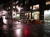
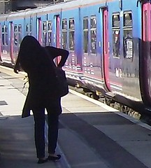 I always carry a camera around with me – as well as my phone. Why? Because you never know when you might see something interesting enough to use as a stimulus for an article. And why both? Because each one gives better results in different lighting conditions. Interestingly, my camera, which boasts a Leica lens, copes less well than my phone in the dark – which is why I used my camera for the night street scenes shown here. I like the slightly out-of-focus effect, and the fact that in one of them the darkness is almost overwhelming. I think if you teach you should encourage your students to always carry a camera of some description with them at all times. And if you are a Head of Department, encourage your staff to do the same. Here are my reasons.
7 reasons to incorporate digital photography into your course
 If I were running an educational technology/ICT course now, I’d make taking and sharing at least one photo a week a requirement for remaining on the course. If booting someone off the course was not an option, I’d tie in a significant proportion of the marks to those activities. All this is impractical, of course. Even if I were allowed to get away with such draconian actions, I wouldn’t want to penalise a brilliant student for not taking a few snaps now and again. But think of the benefits to everyone if digital photography were a key component of a course – any course.
Blogging by email via a phone
Blogging by phone is not ideal under normal circumstances, but is a good way of quickly updating your blog when you need to.
Read MorePictures across the curriculum: After the tourists have gone

In this article, English, Economics, culture, geography and tourism are highlighted.
Like most of the pictures I take, this one was unplanned. I saw all these boats in the evening, as I crossed over the bridge in York town centre. The scene struck me as rather poignant.
But then I got to thinking, it would make a great starting point for several avenues of study, such as:
Pictures Across the Curriculum: Missing Monks
In this series I'm looking at how well-chosen digital photos can be used in different areas of the curriculum.
Today I'm looking a some photos that might have sparked off an historical investigation if I'd had more time.
Pictures across the curriculum: portrait of an artist
 In this series I'm looking at how well-chosen digital photos can be used in different areas of the curriculum. In the first one, I looked at the problem of litter.
This one, however, is about a much more pleasant subject: a local artist.
I visited a beach in Suffolk recently, and came across someone painting the landscape. It was a great occasion to have my camera with me!
So who was it? Read on to find out, and to consider some possible curriculum links.
Pictures in the curriculum: Litter Britain
In this series I'm looking at how well-chosen digital photos can be used in different areas of the curriculum. In this article, the focus is on Environmental Studies, bringing in aspects of health and safety, Media Studies and others.
In The Picture: Curriculum Links Challenge
 You could clearly use this picture to inspire some creative writing in English. But could you also use it any of the following contexts? And if so, how?
Photographing the Curriculum
 Digital cameras have been with us now for well over a decade. But three things have changed in that time.
Firstly, you get a bigger bang for your buck, in terms of image size and quality.
Secondly, cameras on mobile phones have become good enough to mean that people can now dispense with the camera as their means of taking pictures.
Friday Photo: Cycle Hire
 In London we now have a cycle hire scheme. The idea is to get people going by bike rather than car, bus or train. Not a bad idea
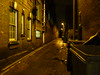
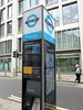
In The Picture: Stop!
 I quite like this picture of a street near the Barbican, London, at night, mainly because it has that three o'clock in the morning feel to it. All that's missing is a newspaper billowing down the street and the sound of a lone saxophone.
Friday Photo: Fans
 I took these photographs of a domestic fan – one in colour, the other in black and white – simply because I liked the look of the pattern.
In The Picture: Help!
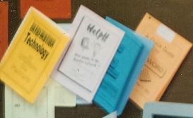 I’m a firm believer in helping youngsters (and colleagues) to become as self-sufficient as possible. As well as being healthy, in my opinion, it is also a requirement of some examination courses.
Friday Photo: Ship in a Bottle
 A ship in a bottle may not sound interesting to you if you’re not of a nautical bent. But one weighing 4 tons?
In The Picture: The Press Association

What sort of technology might you discover on the premises of a media organisation? The answer is not entirely as obvious as you might think…
Web 2.0 For Rookies: Geotagging
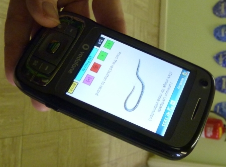
Geotagging is the term given to the adding of geographical metadata to photos, videos, tweets, websites and other media. This ' metadata ' can include longitude and latitude, and other attributes such as altitude. There's a fuller version of this summary information over at Wikipedia , but let's think about the applications of this technology in school.
You can geotag photos, which is a fancy way of saying that you can embed geographical metadata into your digital photos. Have a look at the information -- the metadata - shown below for two photos. One important difference between the two is that the one on the right includes information about where the photo was taken.
 Spot the difference
There are several ways of entering this information in a photo. One is to buy a camera that does it automatically. That's still a bit of an expensive option. Compact models are starting to appear at a price which makes it feasible to consider having two or three in a school for lending out to classes, but not one per class, much less several per class unless the school has a clearly thought-out policy regarding the purchase and use of handheld devices. (For example, Scargill Junior School uses sets of SmartPhones for geotagging photos.) This is a clear example of where allowing youngsters to use their iPhones would make perfect sense, if managed carefully. If the kids have the technology, we should be providing educational opportunities for them to use it. Seems like a no-brainer to me. (There's a good article in the early-April issue of Computers in Classrooms in which a teenager describes how essential his phone is to him. I believe he sometimes even uses it for talking to people!)
Another option is to place your photo on a map in Flickr . This works well, but can be a cumbersome process if there are lots pf pictures to process. Obviously, it would be a good idea to make this process an educational activity in itself: something the geography folk could get involved in perhaps? There's a geotagging group on Flickr , with links about how to use the mapping facilities there.
Yet another approach is to but a wi-fi-enabled storage card, which is what I hope to experiment with soon. This looks like a brilliant option. It's not exactly cheap, though, and at the moment it seems to me that you'd get better value for money by purchasing a new gps-enabled camera than one of the full-works eye-fi cards, even though it would cost you more. I think this is an area where careful research, and some patience, are required.
So what can you actually use geotagging for in education? One obvious answer is anywhere that mapping is relevant. For example, a presentation about a school trip can be made to come alive by placing the photos taken on a map. And school excursions can themselves be made more exciting by the use of geocaching , which is essentially a treasure hunt that makes use of GPS-enabled devices to find hidden objects.
 Get SmartExploration of different habitats in the local area or school grounds can include geotagging the photos taken. In Scargill Junior School, mentioned earlier, the children use the SmartPhones to take pictures of minibeasts , and the exact location of the insects is recorded at the same time, enabling them to find them easily again, and to place them on a map.
Anything involving measures of distance or altitude will not only thrill the geography teacher, but will be welcomed with open arm by the mathematics teachers too. For history teachers, also, the use of geotagging to explore where past battles took place must be an exciting prospect. You could also bring in a discussion of the impact of information technology on society: in England during WW2 rural place names and signposts were taken down so that the Germans would get lost if they managed to land on our shores. (See this set of Yahoo! Answers , especially #3.) How useful would that bluint approach be in this day and age?
Even the artists can get involved. You can find out how by going to Lesson Planet , where a multitude of suggestions for geotagging and using GPS-enabled devices will be found. You have to log in to find out the detail, but there are pages of ideas which subject specialists should be able to make sense of.
An example of geotagging you may have come across is the Clustr map . Seen on numerous blogs , this is a map showing where visitors have come from. Variations may also be found on widgets which proclaim when the last visitor arrived on the site, and where they are accessing it from, and the sort of thing I experienced when taking part in a Classroom 2.0 Live discussion , when as people joined the discussion they were invited to enter their location on a world map.
This kind of thing is, I have to say, terribly exciting! It's fascinating to see how many people in different parts of the world are looking at your stuff. It engenders a sense of curiosity ("What country is that ?" ), and even a sense of responsibility: in some cultures some of the things we say and do would probably cause deep offence.
OK, so geotagging is fun, and educational, but where does Web 2.0 come into it? I think there is the obvious answer that the sort of thing I just mentioned msakes it interesting and more meaningful to collaborate with other people from a different location. On a more everyday level, it's possible to take a photo of something, say a restaurant, review the thing you've taken a picture of, and upload both to a site where anyone looking for a restaurant (say) in that area will come across your review and photo.
My own view is that geotagging is not so much an example of a Web 2.0 application in itself, but it is certainly one that can enhance what I would call the 'Web 2.0 experience'.
Other useful references:
Educational Geo-caching (especially pages 10-13)
JSchools use geotagging , wikis , iPhones to teach
Update on 2010-05-02 04:55 by Terry Freedman, Educational ICT Consultant
Top 10 Things You Didn't Know Google Maps Could Do
Came across this fantabulous article via a tweet by @educatoral. Whilst it's not directly about geotagging as such, it gives you a great idea of the kinds of thing that you can do with Google Maps, thereby taking advantantage of geotagging data and principles.
I love the possibility of being able to superimpose a spreadsheet onto a map (#1 in this list). What a brilliant mashup!